FAA INFORMATION EFFECTIVE 16 MAY 2024
Location
| FAA Identifier: | ILN |
| Lat/Long: | 39-25-40.5000N 083-47-31.6000W
39-25.675000N 083-47.526667W
39.4279167,-83.7921111
(estimated) |
| Elevation: | 1076.7 ft. / 328.2 m (surveyed) |
| Variation: | 07W (2025) |
| From city: | 2 miles SE of WILMINGTON, OH |
| Time zone: | UTC -4 (UTC -5 during Standard Time) |
| Zip code: | 45177 |
Airport Operations
| Airport use: | Open to the public |
| Activation date: | 09/1972 |
| Control tower: | yes |
| ARTCC: | INDIANAPOLIS CENTER |
| FSS: | DAYTON FLIGHT SERVICE STATION |
| NOTAMs facility: | ILN (NOTAM-D service available) |
| Attendance: | CONTINUOUS |
| Wind indicator: | lighted |
| Segmented circle: | no |
| Lights: | PAPI RWY 04L & 22R OPR CONSLY SS-SR. ALL RWY 04R/22L LGTS OTS INDEFLY. |
| Beacon: | white-green (lighted land airport)
Operates sunset to sunrise. |
| Landing fee: | yes |
| Fire and rescue: | ARFF index A |
| Airline operations: | INDEX B SVC AVBL; CLSD TO SKEDD ACR OPS GTR THAN 9 PAX SEATS. 90-DAY PPR FOR UNSKED ACR OPS GTR THAN 30 PAX SEATS - CALL AMGR 937-528-9891. |
Airport Communications
| WX ASOS: | PHONE 937-383-7334 |
| WILMINGTON GROUND: | 121.6 |
| WILMINGTON TOWER: | 119.475 |
| COLUMBUS APPROACH: | 118.85 |
| COLUMBUS DEPARTURE: | 118.85 |
| CLEARANCE DELIVERY: | 128.85 |
| D-ATIS: | 124.925 |
| WX AWOS-3 at I66 (6 nm NW): | 124.175 (937-382-1376) |
| WX AWOS-3 at GDK (18 nm NW): | 118.525 (937-372-4668) |
| WX AWOS-3 at HOC (19 nm SE): | 118.175 (937-393-9038) |
| WX AWOS-3 at I23 (19 nm NE): | 118.775 |
- NO EMERG FREQ
- SURFACE MOVEMENT GUIDANCE AND CONTROL SYSTEM NOT AVBL.
Nearby radio navigation aids
| VOR radial/distance | | VOR name | | Freq | | Var |
|---|
| MXQ at field | | MIDWEST VOR/DME | | 112.90 | | 04W |
| XUBr266/(38.2) | | YELLOW BUD VOR | | 112.50 | | 05W |
| NDB name | | Hdg/Dist | | Freq | | Var | | ID |
|---|
| AIRBO | | 220/4.6 | | 407 | | 07W | | IL | .. .-.. |
| CUBLA | | 048/5.9 | | 299 | | 07W | | HW | .... .-- |
| COURT HOUSE | | 247/21.2 | | 414 | | 06W | | CSS | -.-. ... ... |
| SPORTYS | | 047/28.8 | | 245 | | 04W | | PWF | .--. .-- ..-. |
Airport Services
| Fuel available: | A |
| Airframe service: | MAJOR |
| Powerplant service: | MAJOR |
| Bottled oxygen: | NONE |
| Bulk oxygen: | HIGH/LOW |
Runway Information
Runway 4L/22R
| Dimensions: | 10701 x 150 ft. / 3262 x 46 m
HAS 1000 FT PAVED AREA ON SW END AND 200 FT PAVED AREA ON NE END. |
| Surface: | concrete/grooved, in fair condition |
| Weight bearing capacity: | | PCN 84 /R/C/W/T | | Single wheel: | 100.0 | | Double wheel: | 200.0 | | Double tandem: | 390.0 | | Dual double tandem: | 750.0 |
|
| Runway edge lights: | high intensity |
| RUNWAY 4L | | RUNWAY 22R |
| Latitude: | 39-25.161402N | | 39-26.563252N |
| Longitude: | 083-48.556512W | | 083-47.178820W |
| Elevation: | 1053.0 ft. | | 1076.7 ft. |
| Traffic pattern: | left | | left |
| Runway heading: | 044 magnetic, 037 true | | 224 magnetic, 217 true |
| Declared distances: | TORA:10701 TODA:10701 ASDA:10701 LDA:10701 | | TORA:10701 TODA:10701 ASDA:10701 LDA:10701 |
| Markings: | precision, in good condition | | precision, in good condition |
| Visual slope indicator: | 4-light PAPI on left (3.00 degrees glide path)
PAPI UNUSBL BYD 8 DEGS LEFT & RIGHT OF CNTRLN. | | 4-light PAPI on left (3.00 degrees glide path)
PAPI UNUSBL BYD 8 DEGS LEFT & RIGHT OF CNTRLN. |
| RVR equipment: | touchdown, midfield, rollout | | touchdown, midfield, rollout |
| Approach lights: | MALSR: 1,400 foot medium intensity approach lighting system with runway alignment indicator lights | | ALSF2: standard 2,400 foot high intensity approach lighting system with centerline sequenced flashers (category II or III) |
| Centerline lights: | yes | | yes |
| Touchdown point: | yes, no lights | | yes, lighted |
| Instrument approach: | ILS | | ILS |
Runway 4R/22L
| Dimensions: | 9000 x 150 ft. / 2743 x 46 m
HAS 200 FT PAVED AREA EACH END. |
| Surface: | concrete/grooved, in fair condition |
| Weight bearing capacity: | | PCN 98 /R/B/W/T | | Single wheel: | 100.0 | | Double wheel: | 200.0 | | Double tandem: | 390.0 | | Dual double tandem: | 750.0 |
|
| Runway edge lights: | high intensity |
| Operational restrictions: | CLSD INDEFLY. |
| RUNWAY 4R | | RUNWAY 22L |
| Latitude: | 39-24.863113N | | 39-26.042105N |
| Longitude: | 083-47.701440W | | 083-46.542652W |
| Elevation: | 1042.5 ft. | | 1076.5 ft. |
| Traffic pattern: | left | | left |
| Runway heading: | 044 magnetic, 037 true | | 224 magnetic, 217 true |
| Declared distances: | TORA:9000 TODA:9000 ASDA:9000 LDA:9000 | | TORA:9000 TODA:9000 ASDA:9000 LDA:9000 |
| Markings: | precision, in good condition | | precision, in good condition |
| Visual slope indicator: | 4-light PAPI on left (3.00 degrees glide path) | | 4-light PAPI on left (3.00 degrees glide path) |
| RVR equipment: | touchdown, midfield, rollout | | touchdown, midfield, rollout |
| Approach lights: | | | ALSF2: standard 2,400 foot high intensity approach lighting system with centerline sequenced flashers (category II or III) |
| Centerline lights: | yes | | yes |
| Touchdown point: | yes, no lights | | yes, lighted |
| Instrument approach: | ILS/DME | | ILS/DME |
Airport Ownership and Management from official FAA records
| Ownership: | Publicly-owned |
| Owner: | CLINTON COUNTY PORT AUTHORITY
1113 AIRPORT RD
WILMINGTON, OH 45177-8904
Phone 937-536-1776 |
| Manager: | JEREMY HEARD
145 HUNTER DR
WILMINGTON, OH 45177-9550
Phone 937-366-2114 |
Airport Operational Statistics
| Aircraft operations: avg 83/month * | | 90% | air taxi | | 10% | commercial | | * for 12-month period ending 01 January 2016 | |
Additional Remarks
| - | 4 HR PPR FOR ALL TSNT ACFT DURG OPRG HRS & AFT HRS - CALL 866-931-2337. |
| - | FOR CD CTC COLUMBUS APCH AT 614-338-8537. |
Instrument Procedures
NOTE: All procedures below are presented as PDF files. If you need a reader for these files, you should download the free Adobe Reader.NOT FOR NAVIGATION. Please procure official charts for flight.
FAA instrument procedures published for use from 16 May 2024 at 0901Z to 13 June 2024 at 0900z.
IAPs - Instrument Approach Procedures |
|---|
| ILS OR LOC RWY 04L **CHANGED** | |
download (235KB) |
| ILS OR LOC RWY 22R **CHANGED** | |
download (287KB) |
| ILS RWY 22R (SA CAT I) **CHANGED** | |
download (272KB) |
| ILS RWY 22R (CAT II - III) **CHANGED** | |
download (271KB) |
| RNAV (GPS) RWY 04L **CHANGED** | |
download (247KB) |
| RNAV (GPS) RWY 22R **CHANGED** | |
download (240KB) |
| NOTE: Special Alternate Minimums apply **CHANGED** | |
download (169KB) |
| NOTE: Special Take-Off Minimums/Departure Procedures apply | |
download (164KB) |
Other nearby airports with instrument procedures:
I66 - Clinton Field Airport (6 nm NW)
KGDK - Greene County/Lewis A Jackson Regional Airport (18 nm NW)
KHOC - Highland County Airport (19 nm SE)
I23 - Fayette County Airport (19 nm NE)
I68 - Warren County Airport/John Lane Field (21 nm W)
|
|

Road maps at:
MapQuest
Bing
Google
| Aerial photo |
|---|
WARNING: Photo may not be current or correct
 Photo taken 11-Sep-2012
looking west.
Photo taken 11-Sep-2012
looking west.
Do you have a better or more recent aerial photo of Wilmington Air Park that you would like to share? If so, please send us your photo.
|
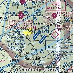
| Sectional chart |
|---|
|
| Airport distance calculator |
|---|
|
|
| Sunrise and sunset |
|---|
|
Times for 27-May-2024
| | Local
(UTC-4) | | Zulu
(UTC) |
|---|
| Morning civil twilight | | 05:41 | | 09:41 |
| Sunrise | | 06:13 | | 10:13 |
| Sunset | | 20:52 | | 00:52 |
| Evening civil twilight | | 21:23 | | 01:23 |
|
| Current date and time |
|---|
| Zulu (UTC) | 27-May-2024 07:44:35 |
|---|
| Local (UTC-4) | 27-May-2024 03:44:35 |
|---|
|
| METAR |
|---|
| KILN | 270654Z AUTO 13009KT 6SM -RA BR OVC110 19/18 A2953 RMK AO2 PRESFR SLP990 P0013 T01890178 $
|
KI23
19nm NE | 270735Z AUTO 17007KT 10SM SCT060 SCT080 BKN110 18/17 A2955 RMK AO1 P0002
|
|
| TAF |
|---|
| KILN | 270521Z 2706/2806 19008KT 5SM SHRA BR OVC035 TEMPO 2706/2708 2SM TSRA BR OVC018CB FM270900 19012KT P6SM OVC015 FM271500 23013G22KT P6SM BKN025 FM271800 25015G25KT P6SM BKN050 FM272200 27014G25KT P6SM SCT080 FM280300 25007KT P6SM SCT250
|
|
| NOTAMs |
|---|
NOTAMs are issued by the DoD/FAA and will open in a separate window not controlled by AirNav.
|
|
