FAA INFORMATION EFFECTIVE 16 MAY 2024
Location
| FAA Identifier: | I73 |
| Lat/Long: | 39-40-55.5950N 084-14-23.9700W
39-40.926583N 084-14.399500W
39.6821097,-84.2399917
(estimated) |
| Elevation: | 720 ft. / 219.5 m (surveyed) |
| Variation: | 04W (1985) |
| From city: | 4 miles SW of DAYTON, OH |
| Time zone: | UTC -4 (UTC -5 during Standard Time) |
| Zip code: | 45439 |
Airport Operations
| Airport use: | Open to the public |
| Activation date: | 10/1947 |
| Control tower: | no |
| ARTCC: | INDIANAPOLIS CENTER |
| FSS: | DAYTON FLIGHT SERVICE STATION |
| NOTAMs facility: | DAY (NOTAM-D service available) |
| Attendance: | DAYLIGHT HOURS |
| Wind indicator: | yes |
| Segmented circle: | no |
| Lights: | SS-SR |
| Beacon: | white-green (lighted land airport) |
Airport Communications
| CTAF/UNICOM: | 122.7 |
| COLUMBUS APPROACH: | 118.85 |
| COLUMBUS DEPARTURE: | 118.85 |
| WX ASOS at MGY (6 nm S): | 118.375 (937-885-2171) |
| WX AWOS-3 at GDK (11 nm E): | 118.525 (937-372-4668) |
| WX AWOS-3PT at MWO (12 nm SW): | 120.025 (513-422-3505) |
| WX AWOS-3PT at I68 (13 nm S): | 120.55 (513-934-5500) |
| WX ASOS at DAY (13 nm N): | PHONE 937-415-6819 |
Nearby radio navigation aids
| VOR radial/distance | | VOR name | | Freq | | Var |
|---|
| DQNr161/21.3 | | DAYTON VOR/DME | | 114.50 | | 01W |
| MXQr311/25.3 | | MIDWEST VOR/DME | | 112.90 | | 04W |
| RODr199/37.5 | | ROSEWOOD VORTAC | | 117.50 | | 05W |
| NDB name | | Hdg/Dist | | Freq | | Var | | ID |
|---|
| ONIDA | | 036/7.3 | | 223 | | 04W | | MW | -- .-- |
| BRUNY | | 162/10.8 | | 315 | | 06W | | AT | .- - |
| SPORTYS | | 002/36.3 | | 245 | | 04W | | PWF | .--. .-- ..-. |
| COURT HOUSE | | 283/39.5 | | 414 | | 06W | | CSS | -.-. ... ... |
Airport Services
| Fuel available: | 100LL
100LL:100LL UNAVBL AFT ATNDD HRS. |
| Parking: | tiedowns |
| Airframe service: | NONE |
| Powerplant service: | NONE |
| Bottled oxygen: | NONE |
| Bulk oxygen: | NONE |
Runway Information
Runway 8/26
| Dimensions: | 3500 x 65 ft. / 1067 x 20 m |
| Surface: | asphalt, in good condition |
| Runway edge lights: | medium intensity |
| RUNWAY 8 | | RUNWAY 26 |
| Latitude: | 39-40.875000N | | 39-40.978167N |
| Longitude: | 084-14.766167W | | 084-14.032833W |
| Elevation: | 720.0 ft. | | 720.0 ft. |
| Traffic pattern: | left | | left |
| Runway heading: | 084 magnetic, 080 true | | 264 magnetic, 260 true |
| Displaced threshold: | 558 ft. | | 136 ft. |
| Markings: | basic, in good condition | | basic, in good condition |
| Runway end identifier lights: | no | | no |
| Touchdown point: | yes, no lights | | yes, no lights |
| Obstructions: | 15 ft. berm, lighted, 201 ft. from runway, 75 ft. left of centerline, 1:1 slope to clear
+15 FT LGTD DIKE 0 FT FROM RY END 85 FT RIGHT TO 200 FT FROM EOR 75 FT LEFT. | | 6 ft. berm, lighted, 201 ft. from runway, 60 ft. right of centerline, 1:1 slope to clear
6 FT LGTD DIKE 0 FT FROM RY END 125 FT LEFT TO 200 FT FM EOR 120 FT R. 15 FT BRUSH 60 TO 100 FT FM EOR 50 FT R. |
Airport Ownership and Management from official FAA records
| Ownership: | Publicly-owned
JOINT PVT/PUB OWNERSHIP. |
| Owner: | MONTGOMERY CO/MORAINE AIRPARK, INC
3800 CLEARVIEW AVE
MORAINE, OH 45439-1199
Phone 937-866-2489 |
| Manager: | BRAD TEMPLIN
3800 CLEARVIEW AVE
MORAINE, OH 45439-1199
Phone 937-866-2489
MANAGER@MORAINEAIRPARK.COM. |
Airport Operational Statistics
| Aircraft based on the field: | | 111 | | Single engine airplanes: | | 104 | | Multi engine airplanes: | | 2 | | Helicopters: | | 1 | | Gliders airplanes: | | 1 | | Ultralights: | | 3 |
| |  | |
| Aircraft operations: avg 72/day * | | 53% | local general aviation | | 26% | transient general aviation | | 20% | air taxi | | <1% | military | | * for 12-month period ending 08 September 2022 | |
Additional Remarks
| - | 15 FT LEVEE S OF & PARALLEL TO RY. TREES N OF RY. |
| - | PAEW ADJ TWYS. |
| - | FOR CD CTC COLUMBUS APCH AT 614-338-8537. |
| - | ULTRA-LIGHT ACTVTY. |
| - | RY 8 & 26, CLIMB STRAIGHT OUT TO 1700 FT MSL. |
| - | +75 FT TREE OVERHANGS PARL TWY BTN TRML & RWY END 26. |
| - | MILITARY JETS OVER ARPT INBOUND & OUTBOUND TO WRIGHT PATTERSON AFB 12 MI NE. |
| - | BIRDS INVOF ARPT. |
Instrument Procedures
NOTE: All procedures below are presented as PDF files. If you need a reader for these files, you should download the free Adobe Reader.NOT FOR NAVIGATION. Please procure official charts for flight.
FAA instrument procedures published for use from 16 May 2024 at 0901Z to 13 June 2024 at 0900z.
IAPs - Instrument Approach Procedures |
|---|
| RNAV (GPS)-A | |
download (176KB) |
| NOTE: Special Take-Off Minimums/Departure Procedures apply | |
download (474KB) |
Other nearby airports with instrument procedures:
KMGY - Dayton/Wright Brothers Airport (6 nm S)
KGDK - Greene County/Lewis A Jackson Regional Airport (11 nm E)
KMWO - Middletown Regional Airport/Hook Field (12 nm SW)
KFFO - Wright-Patterson Air Force Base (12 nm NE)
I68 - Warren County Airport/John Lane Field (13 nm S)
KDAY - James M Cox Dayton International Airport (13 nm N)
3I7 - Dayton/Phillipsburg Airport (16 nm NW)
|
|

Road maps at:
MapQuest
Bing
Google
| Aerial photo |
|---|
WARNING: Photo may not be current or correct
 Photo taken 01-Aug-2006
from a Cessna 340
Photo taken 01-Aug-2006
from a Cessna 340
Do you have a better or more recent aerial photo of Moraine Air Park that you would like to share? If so, please send us your photo.
|
| Sectional chart |
|---|
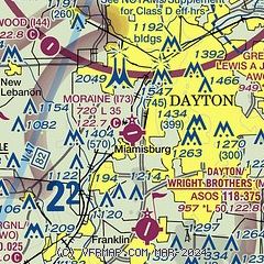
|
| Airport distance calculator |
|---|
|
|
| Sunrise and sunset |
|---|
|
Times for 19-May-2024
| | Local
(UTC-4) | | Zulu
(UTC) |
|---|
| Morning civil twilight | | 05:48 | | 09:48 |
| Sunrise | | 06:19 | | 10:19 |
| Sunset | | 20:48 | | 00:48 |
| Evening civil twilight | | 21:19 | | 01:19 |
|
| Current date and time |
|---|
| Zulu (UTC) | 19-May-2024 04:48:40 |
|---|
| Local (UTC-4) | 19-May-2024 00:48:40 |
|---|
|
| METAR |
|---|
KMGY
5nm S | 190353Z AUTO 00000KT 10SM CLR 19/15 A2993 RMK AO2 SLP128 T01940150
|
KMWO
12nm SW | 190435Z AUTO 00000KT 10SM CLR 16/ A2995 RMK AO2 T0164////
|
KFFO
12nm NE | 182355Z AUTO 34005KT 10SM CLR 26/14 A2987 RMK AO2 SLP113 T02620143 10272 20242 56002
|
KDAY
13nm N | 190356Z 00000KT 10SM CLR 21/16 A2994 RMK AO2 SLP130 T02060161
|
KI68
13nm S | 190435Z AUTO 00000KT 10SM CLR 19/19 A2993 RMK AO2
|
|
| TAF |
|---|
KFFO
12nm NE | 181900Z 1819/2001 05009KT 9999 SCT040 QNH2988INS BECMG 1900/1901 VRB06KT 9999 SKC QNH2990INS BECMG 1907/1909 VRB04KT 6000 BR FEW025 QNH2995INS BECMG 1911/1913 33009KT 9999 NSW FEW045 QNH3000INS BECMG 1917/1918 02009KT 9999 BKN050 QNH2995INS TX27/1821Z TN16/1911Z
|
KDAY
13nm N | 181737Z 1818/1918 06005KT P6SM BKN035 FM190000 03003KT P6SM SKC FM190800 00000KT 4SM BR FEW250 FM191300 35005KT P6SM FEW035 SCT250
|
|
| NOTAMs |
|---|
NOTAMs are issued by the DoD/FAA and will open in a separate window not controlled by AirNav.
|
|


